Identify Ore Deposits Using Lineament Analysis
By combining his knowledge of multiple factors such as geophysics, geology, and geochemistry, Ricardo Valls, President and owner of Valls Geoconsultant, can identify potential ore body deposits for clients with great accuracy. This integrated approach has proven useful in a variety of geological consulting projects Mr. Valls and his team have conducted for private companies and government agencies throughout the world.
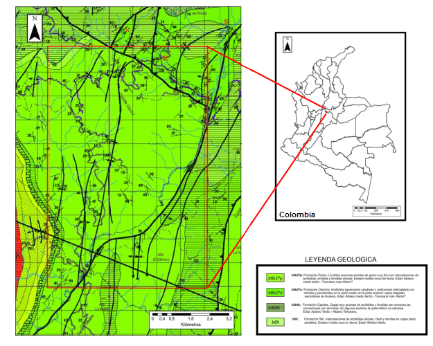
In one such project for Fura Emeralds, Mr. Valls applied lineament analysis and satellite imagery interpretation to search for emeralds in Colombia, South America.
The location of most Colombian emerald ore deposits can be directly connected to main tectonic structures. The mineralization is contained within hydrothermal breccias. On a regional scale, typical structures include anticlines and synclines, representing thrust planes. During the thrusting process, folding and veining occur when hydrothermal fluids circulate in the thrust zones. These folds and faults can be identified on a large scale map.
As such, Mr. Valls and his partner Dr. Vadim Galkine analyzed aerial photography, satellite photography, and topographic maps to identify structures and lineaments to pinpoint potential ore deposits. The number of structures in each area and their intersections were digitized on the aerial map. These digitized values were processed and classified. By mapping these values in Surfer with other pre-existing information they created a new numeric value, the range correlation coefficient (RCC). The location of all prospective zones are displayed by mapping the RCC.
Mr. Valls then used geochemical sampling and interpretation to further reduce the area of interest. With Surfer’s powerful Variogram modelling feature he was able to isolate the areas where mineralization was likely to occur.
By defining compact areas conducive to the formation of emeralds, Mr. Valls and his partner were able to reduce the initial area of interest by 60%. The integrated analysis of geophysics, geochemistry, lineaments, and satellite interpretation clearly defined two prospective areas that are currently being explored.
Exploration work continues by Fura Emeralds. Additional samples, elaboration of the detailed geological map, and further geochemical analysis will be obtained in the much reduced study areas. The plan is to identify the most favorable areas to test for emerald mineralization utilizing a diamond drilling campaign.
Mr. Valls uses all Golden Software programs on a regular basis and finds them indispensable to his work. When asked why he first used any of the Golden Software programs, Mr. Valls commented, “What impacted me was the ease of use. In less than two days, I was able to make Surfer work and understand the program with no help at all!” Over the years, Mr. Valls has been a dedicated Golden Software customer. When asked why, he said, “because of the level of help, the videos on the site, and the quality of the customer service which makes the learning process a breeze. There is nothing in the market that comes close to the quality of Golden Software programs. They are easy to use, well priced and you have, hands down, the best customer service.”
In addition to searching for emerald ore deposits, Mr. Valls’ projects range from local mapping to regional reconnaissance and encompass many facets, including diamond drilling, mapping and sampling for open pit and underground mines, and ore deposit exploration. Mr. Valls is an active member of the Geological Association of Canada, Association of Professional Geoscientists of Ontario, and other geologic associations.
Golden Guarantee
100% Satisfaction Guaranteed or 100% of Your Money Back
We know Surfer and Grapher’s visualization capabilities will help you stand out from the crowd, WOW clients, and leave a lasting impression!
But… we realize you don’t know this yet. And you won’t until you experience our products for yourself.
This is why we provide this guarantee. This is the distillation of a 40+ year adventure designing, developing, and honing powerful visualization and analysis features as requested by scientists and engineers like you.
Our products can produce results far beyond its license fees. We are assuming all your risk, so you have none.


