Details in the Data: How to Show a More Complete Picture of Concentrations & Contaminants in 3D Models
When it comes to visualizing subsurface concentrations and contaminants, 3D models are the best option. Stakeholders can view them to make critical decisions—whether it’s determining the extent of a contamination plume to brainstorm remediation efforts or assessing concentrations of resources to determine where to drill. But here’s the challenge you face in the design process: ensuring all the details are visible because when you’re working with subsurface data, what you don’t see in a 3D model can be just as important as what you do.
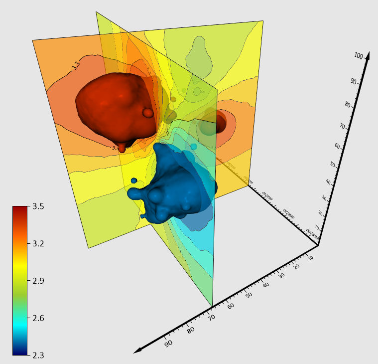
You may, for example, be able to map out contamination plumes using isosurfaces or volume renders, but what about the layers of hydraulic conductivity? Or the pockets of data in between your drillholes? These details inside your 3D models matter—and when they’re not visualized plainly, your stakeholders can get an incomplete picture of what’s happening beneath the surface. That’s a risk no one wants to take.
So, how do you deliver a more complete image of subsurface concentrations and contaminants? You make what seems invisible in your 3D model visible—which is now possible with Surfer.
The Workarounds That Don’t Really Work
Before you could count on Surfer to highlight the hidden details in your 3D models, you had to resort to using creative tips and tricks to get the job done. One approach was using horizontal contour slices to add more context to volume renders. The problem? You couldn’t easily see the contour slices inside the volume render. If your point of interest was somewhere in the middle, it was hard to view. Of course, you could clip the volume render to see the contours more easily. This solution helped — but it left a little to be desired. Ideally, you needed contour slices that were either vertical or at a custom angle, leading to the second workaround you probably utilized: massive geological modeling software packages with a high price tag. These pricey tools could provide the detailed 3D models you needed, but they came with a major challenge: a cluttered interface so robust it wasn’t user-friendly.
At the end of the day, none of the workarounds were ideal. They left you in a tough spot—either you had to use a visual element that didn’t quite deliver what you needed, or you had to adopt expensive software so complex it slowed you down.
The Solution: Contour Slices at Any Orientation
So what’s the solution? It’s giving you the tools to easily create contour slices at any orientation, making it simpler to see the details that fill out the rest of your 3D model’s story. And guess what? Surfer delivers that exact solution.
With this new tool, you’re no longer limited to horizontal planes or stuck navigating challenging geological packages. Want a vertical contour slice to show the concentration levels of carbon tetrachloride contamination at different depths? Done. Prefer to use vertical contour slices to illustrate hydraulic conductivity while your isosurfaces or volume render model groundwater contamination? Simple. Need a custom diagonal slice to highlight a specific trend in your data? Easy. In all instances, you can set a slice’s orientation to fit the exact insights you want to share. You can even adjust a contour slice’s position if it’ll assist in telling your 3D model’s story. Move it forward, pull it backward, tilt it, or rotate it. You can do whatever it takes to showcase your findings clearly and completely, no workarounds or steep learning curve required.
This isn’t just about seeing your subsurface data differently. It’s about delivering a more complete picture of concentrations and contaminants underground, without the extra effort that slows down your process.
Delivering Clearer Subsurface Insights with Less Effort
The difference between a rough overview and a detailed model can be the key to informed decision-making—and it’s up to you to provide that clarity. But as you’ve seen, the usual workarounds for visualizing subsurface concentrations and contaminants in 3D models can fall short. Horizontal contour slices only tell part of the story, and massive geological software packages can feel like overkill, bogging you down with complex workflows.
That’s why easily creating 3D contour slices at any orientation in Surfer is a game-changer. It bridges the gap between surface-level insights and a full, detailed picture of what’s happening underground. Whether you need a vertical contour slice to show a plume’s concentration levels or contour slices at custom angles to highlight specific trends, Surfer’s new update makes it easy to slice through your 3D models and show stakeholders exactly what they need to see.
No more patchwork solutions—just clear, comprehensive visualizations that provide actionable insights. Ready to bring your subsurface data to life more quickly? Download a 14-day free trial of the Surfer!
Recent Articles
- Apr 1, 2026|Gabbie Rhodes|10 min
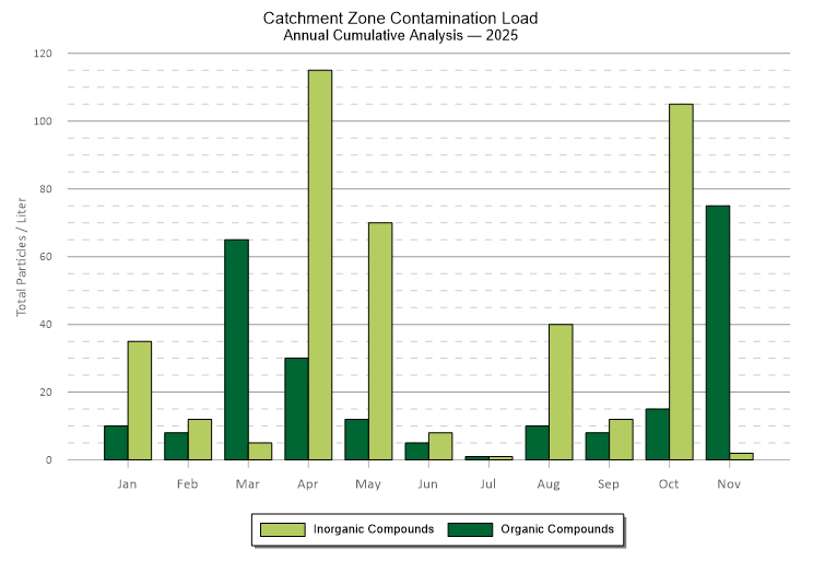
Grouped bar charts offer a distinct and powerful way to compare data. They can bring clarity to differences that might otherwise get buried.
- Apr 1, 2026|Gabbie Rhodes|6 min
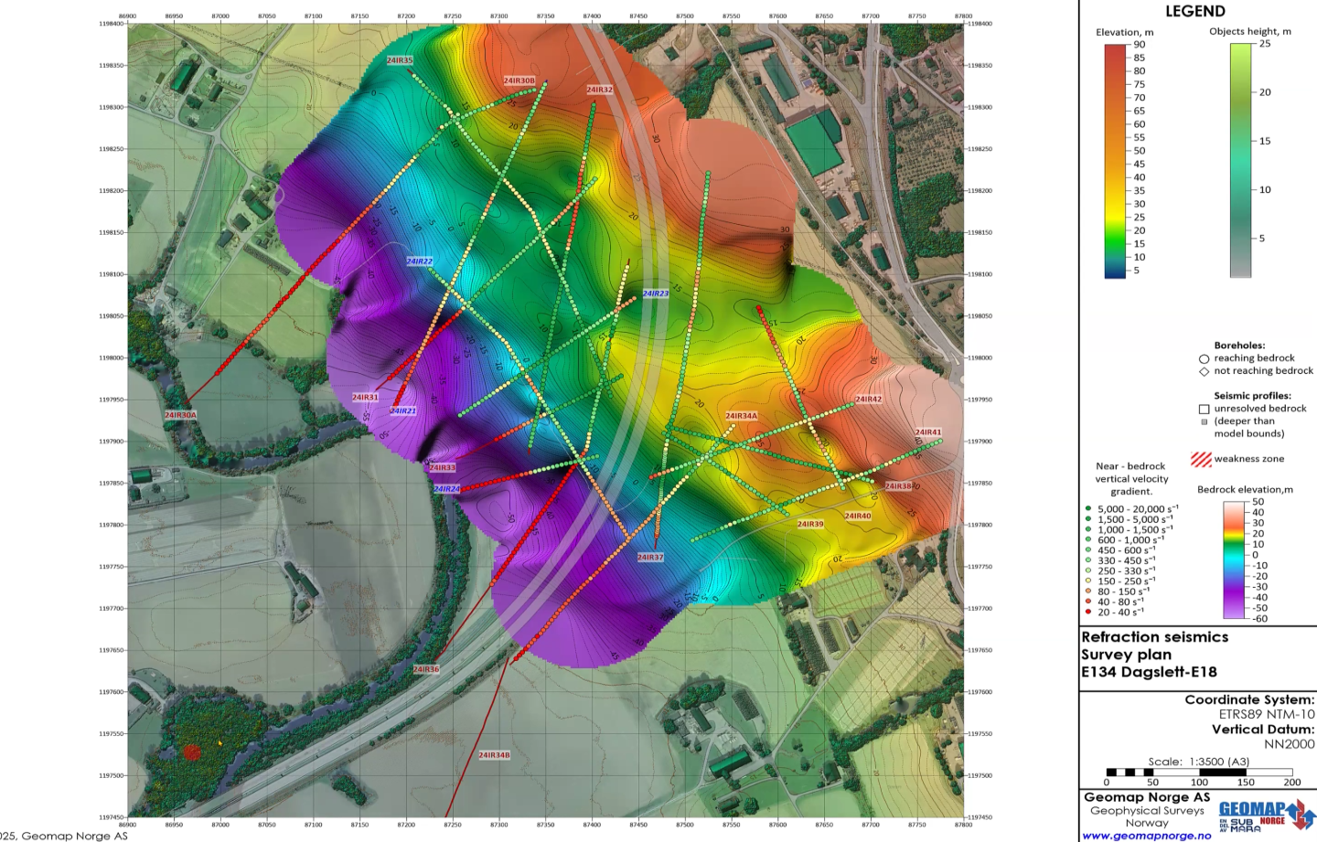
From surface to subsurface features, Alexey Shulgin translates geophysical measurements into clear insight to drive stakeholders' decision-making.
- Mar 25, 2026|Gabbie Rhodes|10 min
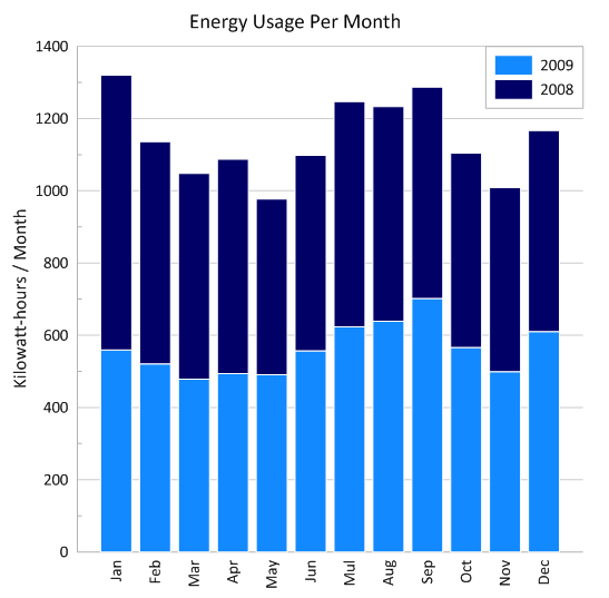
Stacked bar charts are one of those visuals that everyone recognizes but doesn’t always use to their full potential. Discover how to use it effectively.
- Mar 25, 2026|Gabbie Rhodes|11 min
One of the most common choices in scientific data visualization is deciding between a log scale vs. linear scale. Here's how to choose wisely.