Modeling Groundwater Resources in Surfer
Characterizing groundwater resources is a critical step when analyzing potential mining areas. A vital component of the mining process, water is used for mineral processing, metal recovery, dust mitigation, and the basic needs for on-site workers. Even more importantly, a thorough understanding of groundwater resources is a major factor in understanding the environmental impact of the mine on those resources.
One such groundwater characterization project was led by Knight Piésold and company hydrogeologist Jared King. The project entailed the characterization of a decommissioned gold and silver mine in preparation for permitting future mining scenarios.
Over the course of six months, reverse circulation drilling was conducted throughout the proposed future mining areas. At each borehole, a well was installed and groundwater measurements were taken via an electronic water level indicator. All drilling samples, primarily volcanic and sedimentary rock, were characterized onsite by Knight Piésold geologists.
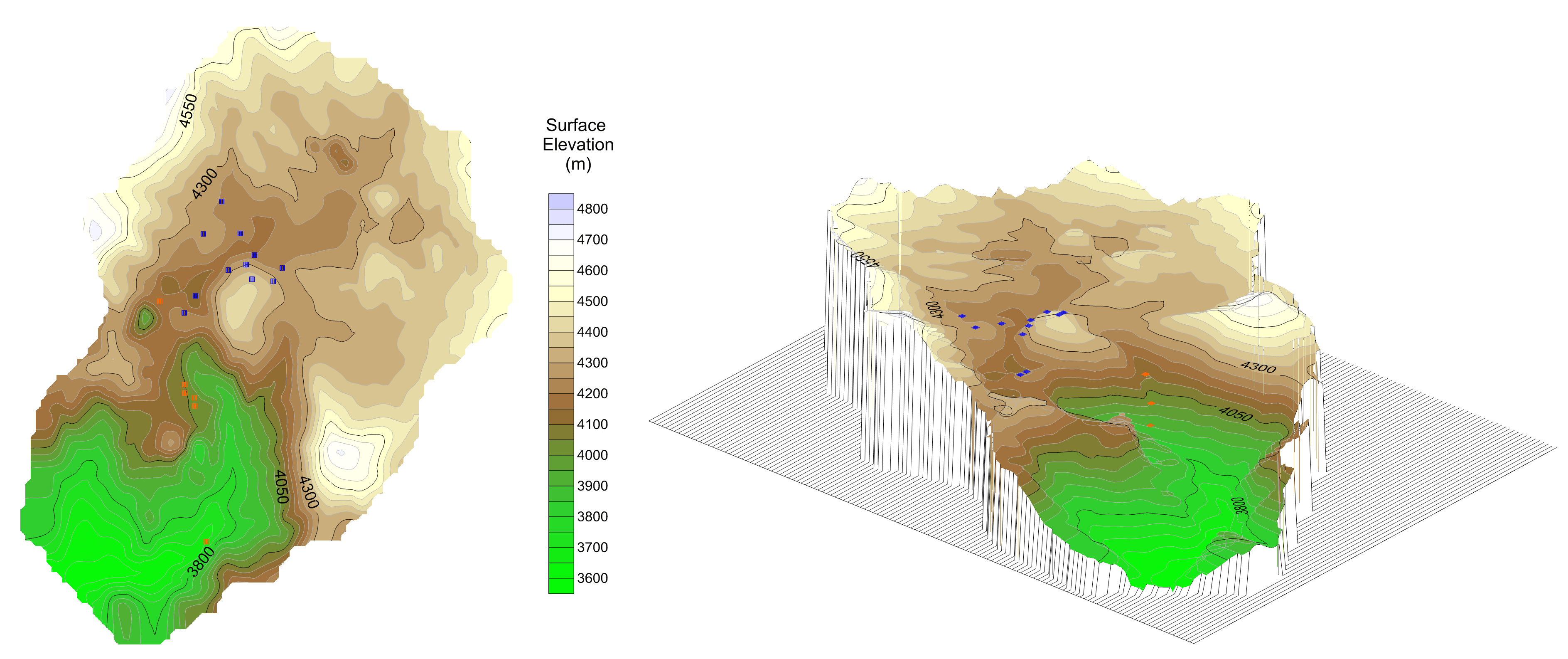
Developing a relationship between the surface elevation and the groundwater elevation was an important step for Mr. King and the team. The site was located in the Atacama region of Chile, an area with historic faulting and wide ranging surface topography with approximately 500 meters of elevation change. Additionally, the high altitude desert climate experienced significant precipitation variation which in turn impacted the shallow and deep groundwater flow. As such, a basic surface elevation map of the site was plotted using Golden Software’s contouring, gridding, and surface mapping software, Surfer.
Due to the highly variable topography of the mine area, Mr. King could not create a groundwater surface using a normal interpolation method as the gridded surface would not match what was observed in the field. Instead, the groundwater level was estimated using an empirical relationship from the data collected during drilling.
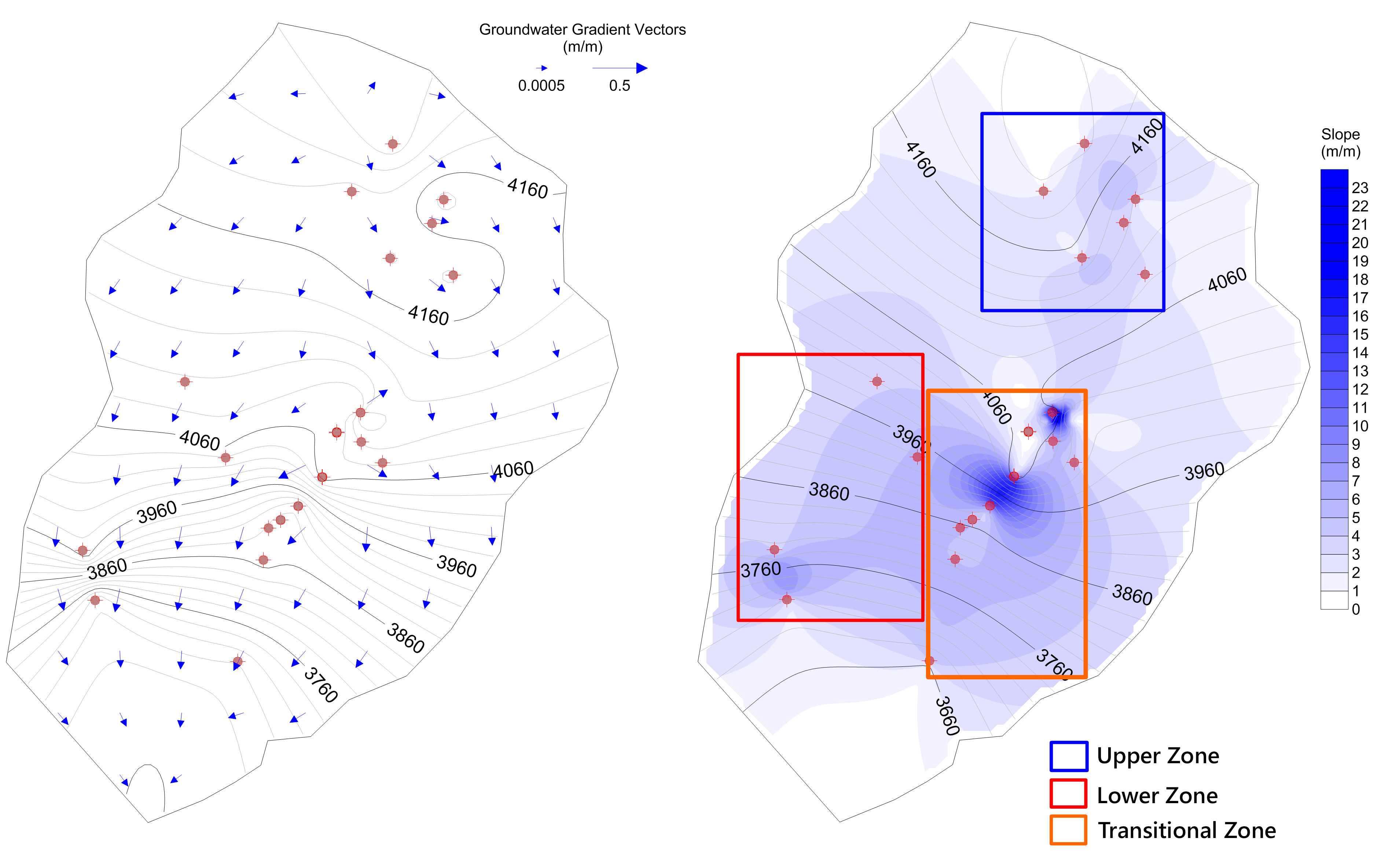
The groundwater depth surface created from the drilling data revealed several different groundwater regions that behaved somewhat independently. They regions consisted of an upper zone with a shallow hydraulic gradient, a lower zone representing shallow groundwater in the valley-fill, and a zone of transition characterized by both steep surface and groundwater gradients.
When the groundwater elevation map was draped over the surface elevation map, a strong correlation was viewed. This allowed the group to conceptually understand how the groundwater behaved throughout the arid, high-elevation mining site.
Additionally, a gradient and slope map was created to better understand the overall flow regime across the study area. These maps also aided in creating a valid conceptual model for the groundwater surface. Another important aspect of the hydraulic system analysis is the presence of springs. The location and elevation of the springs helped to confirm the conceptual model of groundwater flow with separate shallow and deep groundwater systems.
Mr. King and the Knight Piésold team are finalizing their study and preparing the conceptual model report for their client. The next phase will entail the simulation of groundwater flow throughout the site. Three dimensional groundwater models will be created by feeding the surfaces generated in Surfer into MODFLOW, a groundwater modeling program developed by the USGS.
Knight Piésold is an employee-owned global consulting firm that provides specialized services to the mining, power, water resources, infrastructure, and oil and gas industries. The company consists of engineers, environmental scientists, geoscientists, and technologists who focus on creating value at every stage of a project through quality driven, sustainable, and cost-effective solutions.
Golden Guarantee
100% Satisfaction Guaranteed or 100% of Your Money Back
We know Surfer and Grapher’s visualization capabilities will help you stand out from the crowd, WOW clients, and leave a lasting impression!
But… we realize you don’t know this yet. And you won’t until you experience our products for yourself.
This is why we provide this guarantee. This is the distillation of a 40+ year adventure designing, developing, and honing powerful visualization and analysis features as requested by scientists and engineers like you.
Our products can produce results far beyond its license fees. We are assuming all your risk, so you have none.


