Understanding the View: Helping the General Public Enjoy the Geology in Their Surroundings
When you look out at a stunning landscape—towering cliffs, winding valleys, and expansive plateaus—most people don’t think about the forces that shaped it over millions of years. But for retired geophysicist and author Peter Hatherly, that’s exactly what makes these views so fascinating.
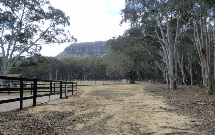
At the Lyrebird Festival in Australia, Peter took the opportunity to help festival attendees appreciate not just the beauty of the Megalong Valley in Australia’s Blue Mountains, but also the geology behind it. Through a story-driven presentation, he connected the dots between the landscapes they were admiring and the powerful geological processes that formed them.
His goal? To make geology engaging and understandable for a general audience—many of whom were artists, musicians, and nature enthusiasts rather than scientists. When we asked for insight into how he did this successfully and what exactly he shared, Peter gave us the rundown, and we’re here to give it to you.
Making Geology Accessible Through Storytelling
Let’s start by discussing how Peter shared scientific insights with festival attendees effectively. Simply put, Peter’s talk wasn’t just about presenting facts. It was about telling a story. By drawing connections between famous landscapes, historical discoveries, and the local environment, he made geology accessible and engaging for a non-scientific audience. Rather than overwhelming attendees with technical details, he used visuals, analogies, and simple explanations to bring complex geological processes to life.
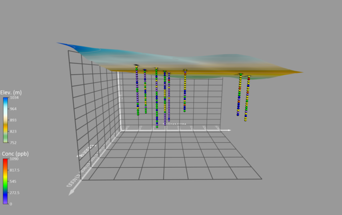
Throughout his talk, Peter also used Surfer-generated visuals showcasing the Megalong Valley’s geology in a way that was both scientific and understandable. The software equipped him to:
- Overlay geological maps onto topographic LiDAR data for a clear, detailed view of how the geology influences the landscape.
- Strip away vegetation with 3D LiDAR mapping to show the valley’s rock layers from multiple perspectives and reveal hidden geological features.
- Illustrate ancient geological processes, like uplift and erosion.
By combining scientific accuracy with intuitive visuals and simple explanations infused with analogies, Peter produced an easy-to-follow story—and it worked well. Instead of glazing over, attendees became curious. They asked questions, exploring the landscape with a new perspective, and seeing the valley as more than just a scenic view.
So, ready to know what exactly Peter shared with attendees? Let’s dive into some of his main topics: the valley’s current geology, the unconformities shaping the land, and the geological changes happening today.


The Story of the Megalong Valley: A Geologist’s Perspective
The Megalong Valley is framed by dramatic sandstone cliffs and smooth slopes. For many, it’s simply a breathtaking view. But Peter wanted attendees to understand why the landscape looks the way it does.
To explain this, he zoomed out and compared the Megalong Valley’s geology to well-known locations like the Grand Canyon in Arizona. Just like in the sunny, arid state, the valley in the Blue Mountains is made up of alternating strong and weak rock layers. The stronger layers form sheer cliffs, while the weaker layers erode more easily, carving out deep valleys over time.
Peter used online imagery and 3D views in Surfer to show how these layers interact, making it easy for attendees to visualize what’s happening above and beneath the surface. He highlighted the Megalong Valley’s key geological formations, including the following:
- Hawkesbury Sandstone and Narrabeen Group – Made up of stronger sandstones, leading to the valley’s characteristic unbroken cliff lines.
- Coal Measures – Underlying layers of interbedded siltstones and coal that undermine the overlying sandstones by erosion and landslides.
- Shoalhaven Group – a sequence of easily erodible marine strata that also destabilize the overlying layers.
- A layer of hard sandstone and conglomerate – This gives the valley its characteristic flat floor.
With airborne LiDAR data, Peter could provide very detailed images of the ground surface beneath the vegetation. He used Surfer to visualize the LiDAR data and reveal hidden geological features, delivering a clear picture of how the different rock types influence the valley’s shape.
“Most people just see the cliffs, pretty trees, and vegetation,” he explained. “They don’t see that there’s similarity between what’s happening here and what’s happening in Arizona where the earth’s processes are obvious because there’s no vegetation masking what’s going on. That’s why I produced the LiDAR-generated map—to show the processes that are occurring in the Megalong Valley.”
Unconformities: Time Gaps in the Landscape
Another one of Peter’s key messages was that rocks and landscapes don’t just form overnight; they’re formed and shaped over millions of years. In the Megalong Valley, he shared with festival goers the concept of unconformities, where rock layers of vastly different ages are stacked on top of each other, representing missing time in the geological record. To illustrate this, Peter referenced James Hutton’s famous discovery in the 1780s at Siccar Point, Scotland, where gently dipping Devonian sandstones sit atop steeply tilted Silurian rocks—a visible gap in geological history.
“James Hutton recognized what he called the abyss of time, where there’s no vestige of beginning and no prospect of an end,” Peter explained.
Just as the Grand Canyon has an unconformity between its inner and outer canyons, the Megalong Valley also has an unconformity at the boundary between the older basement rocks (more than 360 million years old) and the younger siltstones and sandstones (about 260 million years old). This is evidence of ancient uplift, erosion, and deposition that formed these rocks long before humans ever set foot there.
To create this unconformity, Peter explained that ancient glaciers carved away the basement rocks and, in doing so, left their mark on the area. There are massive conglomerate beds at the level of the unconformity, and above this, there are glacial drop stones found in the lower parts of the Shoalhaven Group. These indicate that icebergs once drifted over the region and dropped large chunks of rock to the sea floor when they melted.


How the Valley Continues to Change Today
While the valley’s foundation was set hundreds of millions of years ago, the landscape is still evolving. Peter pointed out that weathering, landslides, and erosion are ongoing processes, shaping the valley even today. Using Surfer-generated visuals and online imagery, he showed evidence of:
- Landslides – Sections of the valley where rock has collapsed due to weak underlying layers. Fans of debris from ancient landslides were easy to spot with the assistance of Surfer.
- Water erosion – Creeks cutting through softer rock, forming gentle channels and steep channels through the stronger rocks.
- Nested valleys – Smaller valleys forming within larger ones as different phases of erosion progress.
These geological processes served as a reminder that landscapes are never static. What we see are just chapters in an ongoing story, and Peter visualized these chapters in real time, helping festival attendees understand how natural forces continue to shape the world around us.
Helping the Public See the Geology Around Them
Ultimately, Peter’s talk at the Lyre Bird Festival demonstrated something important: geology doesn’t have to be complicated. With a story-driven approach that includes simple explanations, engaging visuals, and real-world comparisons, people without a scientific background can easily appreciate the processes that shape our landscapes. And when geologists take the time to tell these stories in a clear, relatable way, it doesn’t just educate—it inspires curiosity and deeper appreciation for the world beneath our feet and all around us.
Want to discover more stories about what’s happening in the world of geoscience? Subscribe to our blog so you never miss an article update!